
|
|
|
|
|
|
 |
|
|
|
|
|
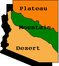
Arizona is the sixth largest state in the United States. It is about 400 miles long and 355 miles wide. It covers almost 114,000 square miles. That's big, but most of the state is not inhabited by people. You will learn that Arizona's land is not all the same. It is divided into three distinct regions.
The southern part Arizona is called the desert region. It gets little rain and is very dry. The plants and animals that live here must adapt to harsh conditions.
The Mogollon Rim separates Southern Arizona from Central Arizona. This is called the mountain region because there are about 30 mountain ranges. The highest point in Arizona is Mt. Humphreys, north of Flagstaff. It is 12,670 feet above sea level.
The third region, found in Northern Arizona, is called the plateau region. We've learned that a plateau is high, flat land. It covers 45,000 square feet. Here, you will find canyons and inactive volcanoes. When you travel to the Grand Canyon, Petrified Forest or Monument Valley, you are visiting the northern plateau.
|
Parks & Park Map - Grand Canyon |
 |
Watchable Wildlife In Northern Arizona
Arizona's Nature Hunt Web Quest
Arizona Department of Library, Archives and Public Records Research Division Museum Home Page
War Relocation Authority Camps in Arizona, 1942-1946
ONLINE Arizona Legislative Information Services